La NOAA ha appena aggiornato le sue prospettive per ottobre. Essendo il mese in cui le prime località del Nord America iniziano ad aprire gli impianti di risalita, speriamo nel freddo e nella neve. E’ questo ciò che otterremo?
Tl;dr: Le previsioni sciistiche di ottobre 2024 indicano temperature più calde del normale e precipitazioni inferiori alla norma in gran parte degli Stati Uniti occidentali e settentrionali, ritardando potenzialmente l’inizio della stagione sciistica in molte regioni.
Nord-ovest (Pacifico nord-occidentale, Montagne Rocciose settentrionali)
Temperatura: Aspettatevi temperature superiori alla norma nel Pacifico nordoccidentale e nelle Montagne Rocciose settentrionali. Si tratta di un cambiamento rispetto alle previsioni precedenti, che prevedevano temperature più fresche per questa regione.
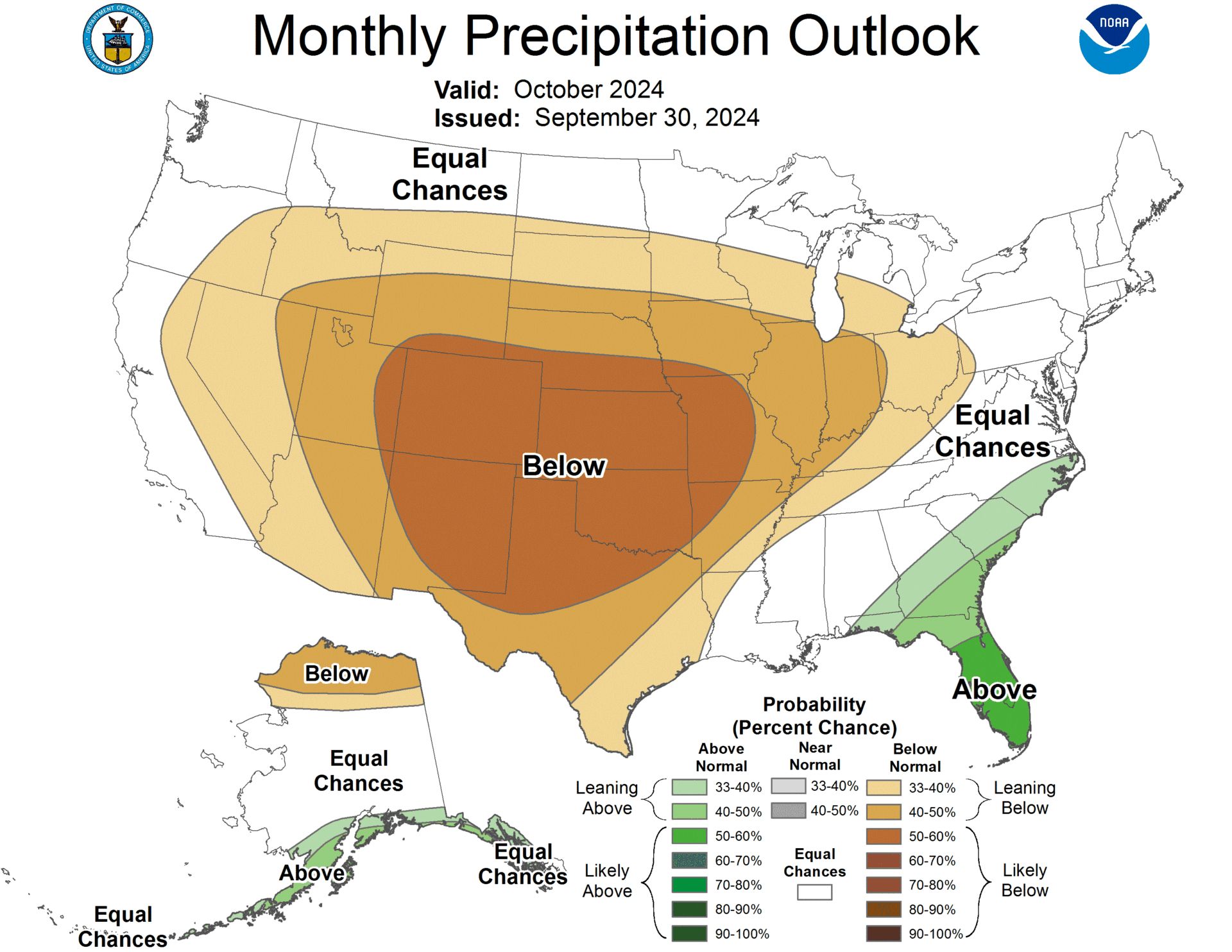
Precipitazione: Sfortunatamente, sono probabili precipitazioni inferiori alla norma per gran parte del Far West, compreso il Pacifico nordoccidentale e le Montagne Rocciose settentrionali. Ciò potrebbe significare un avvio lento della stagione sciistica in queste zone.
Sud-ovest (California, Nevada, Utah, Colorado)
Temperatura: Temperature superiori alla norma sono molto probabili nelle Montagne Rocciose sud-occidentali e centrali. Rispetto alle previsioni precedenti, questa tendenza al riscaldamento si estende più a nord, nello Utah e nel Colorado.
Precipitazione: Le prospettive per questa regione sono piuttosto secche. Precipitazioni inferiori alla norma sono favorite nel sud-ovest, tra cui California, Nevada, Utah e Colorado.
Pianure settentrionali e Midwest superiore
Temperatura: Sono ora previste temperature più calde della media nelle pianure settentrionali e nel Midwest. Si tratta di uno spostamento rispetto alle previsioni precedenti che avevano previsto temperature più fresche per questa regione.
Precipitazione: Precipitazioni inferiori alla norma sono probabili nelle pianure settentrionali e nella valle dell’Ohio. Ciò potrebbe comportare una minore quantità di neve a inizio stagione per aree sciistiche come Minnesota e Wisconsin.
Nord-est e New England
Temperatura: Temperature superiori alla norma sono favorite per le regioni del Nordest e del Medio Atlantico.
Precipitazione: Le previsioni precedenti di condizioni più umide per il Nordest sono state rimosse. Le previsioni ora suggeriscono precipitazioni da normali a leggermente inferiori alla norma per questa regione.
Alaska
Temperatura: È probabile che l’Alaska nord-orientale veda temperature superiori alla norma, mentre l’Alaska meridionale ha una maggiore possibilità di temperature inferiori alla norma.
Precipitazione: L’Alaska sud-occidentale e l’Alaska Panhandle sono favoriti per ricevere precipitazioni superiori alla norma. Tuttavia, nell’Alaska settentrionale, dalla Brooks Range al North Slope, si prevede che le precipitazioni saranno inferiori alla norma.
Prospettive generali per sciatori e snowboarder
Le previsioni di ottobre suggeriscono un inizio impegnativo per la stagione sciistica 2024-25 per molte regioni. Temperature più calde e precipitazioni inferiori alla norma negli Stati Uniti occidentali potrebbero ritardare le nevicate di inizio stagione e gli sforzi di innevamento. Tuttavia, è importante notare che queste sono solo le prospettive di ottobre e le condizioni possono cambiare man mano che ci avviciniamo all’inverno. Sciatori e snowboarder dovrebbero tenere d’occhio le previsioni a lungo termine ed essere preparati per date di apertura potenzialmente successive in alcune località.

La discussione completa è qui sotto:
30-DAY OUTLOOK DISCUSSION FOR OCTOBER 2024 The updated October 2024 temperature and precipitation outlook is adjusted by the availability of medium- and extended-range forecast model guidance within the validation period (i.e. first 2 weeks of October) and the most recent available subseasonal forecast model guidance through the month of October. The temperature outlook for monthly mean temperatures has become considerably more clear as compared to the mid-month outlook. The previous outlook had an above-average amount of "Equal-Chances" (EC) forecast coverage than is typical for monthly outlooks (forecast rationale outlined below in the previous discussion). Forecast ridging and positive 500-hPa height anomalies are consistently forecast during the short-, medium- and extended-range time scales for much of the western and northern CONUS. Above-normal temperatures remain favored for the Southwest, central Rockies, Northeast, mid-Atlantic and the Florida Peninsula as in the mid-month outlook, but odds have increased and forecast coverage more widespread to include the Pacific Northwest, northern Rockies, northern Plains and Midwest. Lower 500-hPa heights, frontal activity, enhanced cloudiness and precipitation are more likely over this period in the Southeast U.S. so EC remains forecast in this region. Although the MJO has evolved generally as forecast in mid-September till now, the response to the mid-latitudes (as defined through MJO composites) is not consistent with the overwhelming medium- and extended-range model guidance noted above. This is not overly surprising for the time of year as noted in the mid-month discussion. The forecast for Alaska remains largely unchanged with enhanced odds for above-normal temperatures for northeast Alaska and enhanced odds for below-normal temperatures (forecast coverage reduced) for southern Alaska. For precipitation, generally only minor forecast changes are made, and the outlook continues to be a quite dry one overall. The favored ridge-trough pattern across the CONUS noted above supports a large area of favored below-normal monthly total precipitation amounts stretching from the Far West eastward across the Plains to the Ohio Valley and southward to Texas. Probabilities are greatest for areas of the south-central High Plains and Great Plains. The outlook is supported by short-, medium-, extended- and subseasonal-range model guidance. Favored above-normal precipitation remains in the new forecast from the previous mid-September outlook for the extreme Southeast including Florida, although for a smaller area, and for southwest Alaska. The forecast in Alaska also now includes an enhanced likelihood of above-normal precipitation for the south coast of Alaska and the Alaska Panhandle as well as favored below-normal precipitation for northern Alaska from the Brooks Range to the North Slope. An additional change in the updated outlook is the removal of the favored wetter than normal conditions originally forecast for the Northeast CONUS - where model guidance now opposes positive (wet) October precipitation trends .